New Zealand; Land Of The Long White Cloud Page 2
I next headed south to Franz Josef Glacier. Nowhere else in the world has a glacier at this latitude advanced so close to the sea. I chartered a helicopter to the top of the glacier where the ice formations, crevasses, and ice caves are most prevalent. The key was to walk very carefully on the slippery ice while photographing and incorporating the few other people in my group into the landscape. Even with crampons on and a walking cane, the trekking was very tricky. A polarizing filter was essential and I made a point of bracketing all of my photos due to the ever-changing light that reflected off the snow and ice. The aerial photographs I was able to get from the helicopter gave a great perspective on the entire glacier and the mountains that surround it.
 |
|
|
Heading farther south toward Fiordland I had numerous incredible experiences along the way outside of Wanaka and Queenstown. Boating trips on turquoise lakes, watching bungee jumpers outside of Queenstown, and incredible walks on invigorating nature trails were all part of the daily routine. One day, outside of Wanaka, I hiked the Rob Roy track, which led me past waterfalls and to a spectacular glacier. I saw an avalanche take place right in from of me. And yes, I did get the photograph!
 |
|
|
The second week I arrived in Fiordland, a glorious collage of undisturbed
mountain-rimmed fiords, sleepy beachside towns, coastal forests, and dramatic
ocean bays. I based myself in the town of Te Anau and embarked on exciting road
trips along Milford Road, which led to the famous Milford Sound. I decided to
charter the smallest boat possible, knowing that would enable me to get closer
to the shoreline for dramatic shots of the high, sheer weather-scuffed cliffs
and peaks that surround it. Using my 20mm wide angle lens and shooting straight
up the cliffs gave the photographs the kind of perspective and impact I wanted.
The final leg of the journey led to me to the Lake Tekapo and Mount Cook National
Park areas. When I arrived at Mount Cook it was raining heavily, so rather than
trek that day I drove one hour to Lake Tekapo and based myself there for the
remaining three days. This proved to be a good move since the weather was perfect
here for landscape photos. The picturesque lake had snowcapped mountains in
the background and fields of lupine in the foreground.
 |
|
|
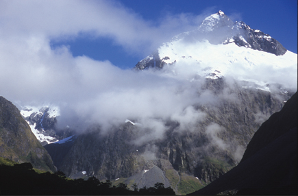
Whenever I embark on long trips of this type I never make hotel reservations. This gives me the freedom to come and go whenever I want when things don't turn out like I planned. Eventually the weather cleared out at Mount Cook and I was able to spend two full days on the Hooker Valley and Tasman Valley trails that I had been looking forward to so much. Of the 27 New Zealand mountains stretching over 3050 meters high, 22 are in this park, with Mount Cook the highest at 3755 meters. Surrounded by the beauty of these dramatic mountains and the ever-present glacier I was inspired to shoot nonstop the entire time. The greatest challenge as I got closer to Mount Cook was staying on my feet--the winds rose to 60 knots and higher!
 |
|
|
My road trip around the South Island will always stand out as one of the most
memorable journeys of my life. Traveling around New Zealand is relatively easy
and it was comforting to be in a country where the environment and nature are
worshiped. One of the goals of my photography is to always try to preserve and
protect the last wild places on earth by showing people the great beauty we
could possibly lose. New Zealand reassured me that there are still countries
where you can go and explore and feel nature's presence everywhere you
go.
At Daryl Hawk's website, www.darylhawk.com,
you can find out more about his travel, fine art, and commercial photography
as well as information about booking him for speaking engagements. You can also
order his recently published book titled "Distant Journeys," which
features his favorite 150 color images from his world travels.
- Log in or register to post comments
