I like the valuable information you provide in your articles. I would bookmark your weblog and check again here frequently.www.plagiarismsoftware.net
- REVIEWS
Camera Reviews 
More Reviews Mobile Reviews Photography Reviews - GALLERIES
- VIDEOS
- BUYER'S GUIDES
Aerial Photography Honored: With USPS Earthscapes Stamp Release
The United States Postal Service (USPS) will release a sheet of 15 “Earthscape” stamps in 2012 celebrating the beauty of the country from “sea to shining sea.” The images, using photographic platforms from ultralites to satellites, focus on natural, agricultural, and urban landscapes from virtually every region. Release is tentatively scheduled for October, 2012, in conjunction with National Stamp Collecting Month.
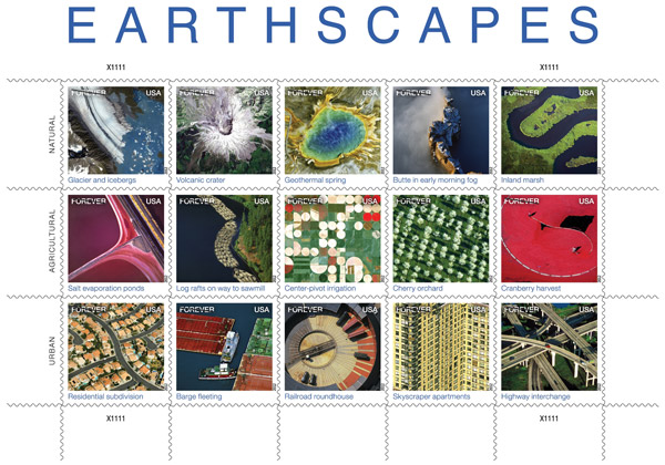
The Earthscapes stamp series.
Courtesy of USPS
Courtesy of USPS
Art director Howard Paine said he chose photographs to showcase designs or patterns and geographic diversity. Paine, who has art-directed hundreds of USPS stamp projects for over 30 years as a contract employee, didn’t seem concerned about miniaturizing to postage-stamp size images usually displayed as large-format prints, posters, or in coffee-table books.
“Over the years, it hasn’t been unusual for stamp projects to portray large subject matter. For a sheet such as this, the images have to be lively in variety, but must also complement each other. Careful cropping, image simplicity, contrast, and color saturation are critical,” Paine said.

Ice breaks from the foot of Alaska’s Bear Glacier and becomes icebergs in a lake. Dirt and rocks picked up by the glacier when it moves downhill can be seen at the edges and center of the glacier and in some of the bergs. The image was captured by the IKONOS satellite.

In Washington State, Mount St. Helens and its surrounding area continue to recover from the explosive eruption of May 1980. Shades of white and gray indicate still-bare slopes; dark “rivers” are deep channels cut by fast-moving flows of hot ash, rock, and gas. Green represents regrowth of vegetation. The image was captured by NASA’s Landsat 7 satellite.
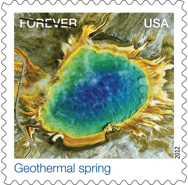
At the center of Grand Prismatic Spring in Yellowstone National Park, water temperatures reach nearly 190 degrees F—too hot to support most life—but along the edges of the pool, bacteria and algae can thrive, as indicated by the colorful pigments and mats they produce. The photograph was taken by Jim Wark.
A USPS 15-member Citizens’ Stamp Advisory Committee made the decision to develop the series. It was then handed over to contract photo editors and researchers tasked with locating suitable images. A call for images did not go out to the photographic community. “I think you can imagine the volume of submissions we’d receive. We simply don’t have the resources to undertake that kind of review process,” Paine said.
The photo staff provided Paine with the hundreds of images he winnowed to find the final 15. Those selected came from a wide variety of sources—including the Landsat 7 and IKONOS satellites, stock images, and six photographers, one of whom provided five of the 15 images.
Eighty-year-old Jim Wark (airphotona.com), Pueblo, Colorado—who produced “Geothermal Spring,” “Butte in Early Morning Fog,” “Barge Fleeting,” “Railroad Roundhouse,” and “Skyscraper Apartments”—spends hours in his plane looking for great shots. When he finds them he said he simply grabs his camera, opens his window and starts shooting. “I’m looking for the pictures that the other guy doesn’t have,” Wark said.
Other photographers in the series include Cameron Davidson whose “Inland Marsh” was made with Fuji Velvia shot from a Cessna 177 modified for aerial photography. The image was made for a large-format photo book about the Chesapeake Bay.
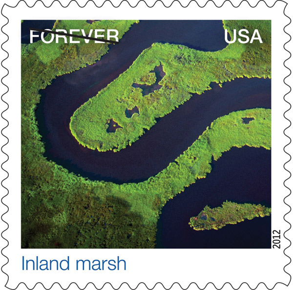
A shallow creek winds through Blackwater National Wildlife Refuge on Maryland’s Eastern Shore. Rich tidal marsh makes up much of the refuge’s more than 25,000 acres, forming a haven for fox squirrels and bald eagles and a stopping-off point for ducks and geese migrating along the Atlantic Flyway. The photograph was taken by Cameron Davidson.

Salt is harvested from seawater in evaporation ponds near San Francisco, California. As natural evaporation occurs, salinity levels increase and the concentrations of algae and other microorganisms in the water change, causing the ponds to take on vivid colors. The photograph was taken by Barrie Rokeach.

“Islands” of wood—log rafts made up of harvested timber—travel by water toward an Idaho mill for processing. This older method of transport has largely died out. Today the timber industry relies on rail and roads to transport trees and tree products from forests to sawmills. The photograph was taken by Tom Brakefield.
“I am a pilot, but I don’t feel it’s safe to fly and shoot at the same time. The majority of my aerials are shot from turbine helicopters,” Davidson said. For details about Davidson’s book, visit aerialchesapeake.com.
Barrie Rokeach (rokeachphoto.com) shot “Salt Evaporation Ponds” near San Francisco. In contrast to Davidson’s method, Rokeach said, “I hand hold the camera, fly and photograph simultaneously. I’m a pilot with commercial and instrument ratings and usually use high-wing Cessnas.”
Unlike Davidson and Rokeach, Tom Brakefield used a less stable platform for his “Log Rafts on Way to Sawmill.”
“The shot was taken hanging out of a tiny micro-light kite as we were bounced from pillar to post in the steep canyons of the Columbia River along the Washington-Idaho border,” Brakefield said. He shot with Fuji Provia. For a look at Brakefield’s stock images, click on inmagine.com.
Richard Hamilton Smith (richard hamiltonsmith.com) photographed a Door County, Wisconsin “Cherry Orchard” from a rented Cessna 172 with Fuji Velvia. Hamilton Smith said that the shot was made for a large-format photo book on Wisconsin. This particular image didn’t make it, but another from the shoot did.
Steve Dunwell (stevedunwell.com) reported that “Cranberry Harvest” was made in late September, 1992, from a helicopter at approximately 500 feet. At the time, Dunwell said, he was working on a series of aerial landscape photographs of distinctive Massachusetts South Shore scenes for an annual report for a local bank. His film? Kodachrome.

Spring is cherry blossom time, and at this cherry orchard in Door County, Wisconsin, every tree seems to be in bloom. Door County is known for its tart red cherries, usually harvested from about mid-July to mid-August. The photograph was taken by Richard Hamilton Smith.

A Massachusetts cranberry bog holds a bounty of ripe red fruit. During the fall harvest, growers flood bogs, then mechanically churn the water to dislodge cranberries from their low-lying vines. They round up the floating fruit with booms, and convey it to receiving stations for cleaning. The photograph was taken by Steve Dunwell.

Endless rows of balconies and windows dot the Manhattan cityscape. In this detail of a photograph, the camera’s telephoto lens compresses the distance between the towers of a high-rise apartment complex on the Upper West Side. The photograph was taken by Jim Wark.
Advanced imaging technology is also represented in the stamp series in the form of three satellite images. Bear Glacier (“Glacier and Icebergs”) is one of 40 glaciers flowing off the vast Harding Icefield located 130 miles south of Anchorage, Alaska—the largest in North America and a 300-square-mile vestige of the last Ice Age. The GeoEye IKONOS satellite made this 1-meter resolution image in 2005 flying 423 miles above the Earth at an average speed of 17,000 mph (geoeye.com).
“Volcanic Crater” and “Center-pivot Irrigation” were made by the Landsat 7 satellite operated by NASA (landsat.gsfc.nasa.gov). The crater is Mount St. Helens imaged in 1999—19 years after it erupted—leveling over 200 square miles of forest, leaving the surrounding landscape barren and the mountain 1300 feet shorter.
Center-pivot irrigation systems created the circular patterns in cropland near Garden City, Kansas. The red circles indicate irrigated crops of healthy vegetation. Light-colored circles represent harvested crops. The image was made in 2000. “Residential Subdivision” and “Highway Interchange” are two stock images that round out the 15 stamps placed in three rows of five.
Lorin R. Robinson’s day job is Professor of Marketing at the University of St. Thomas, Minneapolis, Minnesota. His passions include photography, flying, adventure travel, and travel writing.
- Log in or register to post comments

Center-pivot irrigation
Submitted by usman600 on January 15, 2013 - 9:54pm
Center-pivot irrigation systems cropland near created the circular patterns in cropland near Garden City, Kansas. The red circles indicate irrigated crops of healthy vegetation. Light-colored circles represent harvested crops. represent harvested crops. The image was made in 2000. “Residential Subdivision” and “Highway Interchange” are two stock images that round out the 15 stamps placed in three rows of five.Lorin R. Robinson’s day job Minneapolis, Minnesota is Professor of Marketing at the University of St. Thomas, Minneapolis, Minnesota. His passions include photography, flying, adventure travel, and travel writing.
Nice to be visiting your blog
Submitted by gilberthenry90 on March 3, 2013 - 8:46pm
Nice to be visiting your blog again, it has been months for me. Well this article that i've been waited for so long. I need this article to complete my assignment in the college, and it has same topic with your article. Thanks, great share.
Cell phone spy
Text Messages Spy
There are lot of factors to
Submitted by clark12 on March 10, 2013 - 7:54pm
There are lot of factors to consider when entering this job, being a photography is really great.The shots here are awesome and the angle is really impressive.
Android Spy
To be a photographer it's
Submitted by richard4 on March 25, 2013 - 9:50am
To be a photographer it's nothing unusual, but to hold the camera, fly and photograph simultaneously, it takes a lot of courage and skill. Not to mention that you must also capture the best view. I bet the feeling is great, perhaps I'll try it myself, but only after I'll take whale photos in maui, this summer.
You love your work
Submitted by elizbath martin on April 9, 2013 - 11:57pm
I think this is called art. How easily you share your thoughts in picture. The artist do work is not all about motorcycle accessories
products. Model products you shows its about society and place where we leave.
M6 Net Review
Submitted by kishor on May 16, 2013 - 4:25am
This link is Very Informative
M6 Net Review


PHOTO OF THE DAY

Today’s photo is Grooming by Linn Smith
eNEWSLETTER SIGNUP
![]()
Get the Latest Photo Tips, News & Reviews from Shutterbug!
| Camera Reviews Other Reviews | Mobile Reviews Photography Reviews Columns | News | Features | How-To | Resources |
 © 2025 Shutterbug
AVTech Media Americas Inc., USA
All rights reserved